Geomorphology

The small town of Montalbano Jonico is located on a marine terrace. Around 1million years ago the present location of Montalbano was below the sea level, then the area uplifted and the sea withdrew to the present shoreline.
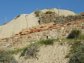
Heading up towards the town from the Agri river Valley, you are travelling on an ancient and well trodden path, this in local dialect is called the “Appiett’ u mulin” (a marvelous mule track that links the cultivated fields to the old town) and when walking one can clearly observe, from the bottom to the top of the slope, a clear lithologic change from clayey to sandstone and conglomerates deposits. This clearly displays the transition from a deep seabed area to a far shallower coastal plain.
The town developed on a surface slightly inclined towards the sea that shows the receding phase of the sea, back to the present day coastline. The entire area of the Montalbano badlands represents the outcome of a process by which agents of erosion have shaped the argillaceous slopes.

Deep gullies, sharp edges and steep walls characterize this rugged and suggestive landscape. Here and there within the clayish rocks there are underground passages and pipes which constitute a typical form of subterranean erosion, similar to karst phenomenons. These are the result of the steady seepage of water into the cracks and fissures of the clay, and their subsequent disintegration and desiccation.
Within the badlands area, it is possible to observe all of the different stages of the geomorphological evolution of the clayey slopes that distinguish this most extraordinary and unusual landscape.
Sharp ridges called “knife -edge divides” clearly represent the early stages of the erosive activity, whereas roundish forms called “elephant backs” are the final stages of the ongoing process. Thus one can find striking shapes of drainage pattern like fishbone, radial and/or comb forms.

Unfortunately the majority of the badlands area is particularly susceptible to landslides that threaten the stability of the old town. These arise in the contact zone between the clay strata and the sandy/conglomerate terraced sediments, since the wet clay represents a “sliding layer” which can act as a sliding bearing for the sediment layers above.

