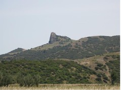
"Tempa Petrolla" Crag
To the northwest side of the reserve, in the borderland between Montalbano, Craco and Pisticci, a spectacular sheer crag called “Tempa Petrolla” (in dialect P’trodd) stands out very clearly from the surrounding countryside.
The cliff is made up of calcareous flysch formed during the Tertiary period by the sedimentation of turbidites in a deep sea basin, developed during the Apennines orogenesis.
Throughout the last evolutionary phases of the Apennines, these stratified rocks, which had detached from its original geological basin (some hundreds km westward), found itself relocated in its present position in the Bradanic Trough, amid the clayey rocks during the Pliocene and Pleistocene transition age. This huge rock has no place being where it is.

The uplift of the Bradanic basin, the retreat of the sea, and the subsequent erosional agents such as wind and water have eventually brought to light this crag.
Apart from the geological importance of Tempa Petrolla, this place is particularly impressive since this huge rocky spur rises astonishingly from the clayish soil , as if it was an alien
meteorite fallen into a sea of clay.
The surrounding region has been inhabited since the Neolithic times, and the presence of many fortified villages until the Middle Ages gives evidence of the strategic position of the local towns in the area, on important passing trade routes. Thus it is possible from Tempa Petrolla to see the Norman tower of Craco, the Swabian castle of Pisticci, the fortifications of Montalbano as well as the castle of San Basilio, an important outpost along the path which leads from the coast, inland. The Tempa Petrolla is located on a watershed between the two rivers, the Agri and Cavone. It is a strategic point of reference for the Italian geodetical network.
From its top one can also enjoy the most fantastic 360° panoramic view, from what is thought to be the fortified remains of a brigands hideaway, high on the top of the rock.


